Last Friday and Saturday (June 22 and 23, 2012), Dan and I joined some friends for a trip to Harpers Ferry, WV, where we stayed overnight in a house owned by the Potomac Appalachian Trail Club. The house is called “Highacre” or “High Acre” and is administered as part of their network of cabins but is not primitive at all; it has running water, electricity, and a well-equipped kitchen. (No air conditioning, though, and there’s only one bathroom for a house that sleeps eight.)
We went with three other couples, who all stayed for three nights (Thursday through Sunday); Dan and I, having felt the stresses of overscheduling in recent weeks, elected to drive up early on Friday morning and return to Charlottesville late Saturday night. On Friday, all eight of us went on a paddling trip together on the Potomac, starting a little way above its confluence with the Shenandoah at Harpers Ferry and continuing down past the confluence and through several rapids. On the second day, the group broke up to pursue various activities, including hiking, flea market shopping, biking, and loafing around the house. Dan, Pete, and I did a second day of paddling, doing a run known as “Staircase” that starts on the Shenandoah above Harpers Ferry and goes down to the confluence. We took out on the Potomac not far past the confluence.
The couples on the trip were: Iva & Bill, Pete & Steph, Rob & Jolie, and Dan & me.
I snapped pictures at various times throughout the trip, but for the most part, I only have pictures of the boring (flat water) parts, because when we came to the rapids, I was too busy paddling to work the camera!

Friday started out overcast and stayed that way for most of the day, but was hot. Here’s a view down the Potomac to the Potomac Water Gap. I am paddling my yellow kayak, a bit of which is just visible in the lower left corner of the picture. Dan is in an orange kayak borrowed from Iva, on the right.

Dan and me. I think we took this picture shortly after running one of the first few rapids, an easy wave train. I am wearing a cap from the U.Va. Engineering School that I got when my company sent me there to recruit interns at one of their career days. Iva, who works at the Engineering School, did not comment on the cap all weekend, and I forgot to point it out to her!

Hanging out, looking towards the Water Gap still. Pete, our leader, in the blue boat ahead. You can see my paddling helmet and water bottle strapped to the bow of my kayak. I keep all equipment attached to either the boat or myself.

Looking back from the Potomac-Shenandoah confluence at Highacre, perched on the hill.

A broader view of Harpers Ferry from the confluence. To the left, the Shenandoah, with one old bridge piling visible. To the right, the Potomac. There are two bridges (both currently in use) visible across the Potomac here. The one in the foreground carries both rail traffic and foot traffic (the AT runs across it). The one behind it carries just the railroad. We sat and ate our lunches on some rocks in the river with this view of Harpers Ferry.

One of many large herons we saw along the way. At times, we had four herons within sight around us.

Dan resting on a stretch of flat water.
After the above picture was taken (I think) we ran through some of the biggest rapids of the day. A well-known one, called White Horse, is considered a class III rapid at higher water (link to classification info) but at the low levels we were running is a straightforward class II. Some people even run it in inner tubes with their toddlers (YouTube link). We all made it through White Horse successfully, using our kayak skirts to keep the water from the 1-2 foot waves out of our boats.
Farther downriver we came to another drop not as big as White Horse in terms of water flow but still significantly higher than anything on the rivers I usually paddle around Charlottesville. Pete and Steph went through the chute first and observed a submerged rock that was difficult to spot. Apparently Pete was paddling back to signal us to run a part of the chute away from the rock, but I saw that Pete and Steph had gotten through the rapid easily and I didn’t realize that Pete was coming back with a message, so I paddled ahead. As I went over the drop, there was a BAM! and my boat came to a sudden, but brief, stop. (Steph asked me later if my neck felt OK. It did. Never occurred to me that a whiplash injury could be a risk of paddling.) Apparently the prow of my boat had met the immovable rock and it was like running into a wall. After stopping for a fraction of a second, my boat sort of fell to one side of the rock and I went through the rapid in a disorganized fashion, let us say. Pete later commented that I had “fought valiantly” but after compensating for balance from side to side a few times I finally overcompensated in the wave train below the drop and tipped over to my left. Ah well–it was frustrating to lose control and the collision with the rock consternated me, but the capsize itself was no big deal. I swam with my boat to a pool of calm water in some rocks below the rapid and set about the business of draining the boat. I emerged unscathed except for a small bruise on one knee from hitting a submerged rock shortly after capsizing, as I was drawing my legs up for the “whitewater swim.” (When you find yourself swimming through rapids, you should float on your back with your feet near the surface and pointing downstream. This keeps you from snagging a foot in a crevice on the bottom of the river, which can be very dangerous, and allows you to bounce yourself off obstacles using your legs as shock absorbers instead of “finding” rocks with your face.)
That was the only “wet exit” or as I like to say “unplanned swim” of the day. The other paddlers behind me avoided the rock by taking a different line through the chute or by picking a different chute through the rocks (there were at least a few to choose from). Pete commented that his and Steph’s whitewater boats had been able to skim over the rock I hit because of their scooped prows and shorter overall boat length, but the combination of my boat’s length and its knife-like prow perfectly suited it for catching the rock as I descended the drop.

Farther downriver we paddled through a fairly calm area dotted with rocky islands. We stopped at one cluster of islands with a five foot deep pool nearby and took a cool-off swim in the pool. In the distance, I observed this bare stump (small light-colored object in the center of the photo), which I thought resembled a cat sitting on its haunches, facing right.

Near the end of the float there was a longish flat, shallow stretch where most of us hopped out of our boats to wade or float for a last cooling-off dip before takeout.

Steph (on the left here) did the classic “hang off one end of the boat” technique while Dan (not visible in this picture, I don’t think) stayed in the cockpit of his borrowed boat and snoozed in the sun.

Later Steph enjoyed “Queen of the Nile” treatment from Iva and Jolie on the approach to the boat ramp where we took out.

Boat ramp. Guys discussing cartop loading logistics.

I just recently bought a used roof rack and one pair of J-shaped kayak cradles off Craigslist. My goal was to be able to carry two kayaks at a time on the roof of my car. Little did I suspect (but I should have!) that Pete would contrive to load the car with three . . .


. . . or even four boats for short trips!

Proud owner of the little Civic that could!

From Highacre, we had a view over the ruins of an old church and down the Potomac. I took this photo on Friday evening.

A hand-drawn map from the days when the house was privately owned.

View from Highacre on Saturday morning.

Zoomed-in view down to the rapids on the Potomac.
On Saturday morning, we parked my car near the bank of the Potomac not far downriver from Harpers Ferry, and then Rob dropped off Pete, Dan, and me with our boats at a public ramp on the Shenandoah.

The first stretch we paddled was flat.


Dan and I took pictures of each other while Pete took a dip in the river.

It was a pretty day and not as muggy as Friday.


fter passing through some relatively small rapids (they would have been pretty exciting by Rivanna standards), we came to the biggest drop of the day: Bull Falls. At Bull Falls, at the water level we were paddling, there are several chutes of water alternating with ledge rock islands. We started by landing on one of the rock islands and scouting the main chute on the left side of the river. Then we took turns paddling through the smaller center chute.

Here’s the center chute.
Pete went first while I took video. Sorry about that small tree blocking the frame.
I went next while Dan did a great job of taking video.
Finally Dan took his turn paddling the chute. Meanwhile, I hit the wrong button on my own camera and didn’t get the video started quickly enough. (This just minutes after showing Dan how to operate the video, which he did perfectly.) I just managed to catch Dan paddling out of the chute at the bottom. Sorry, Dan!
After each person went through, he or she would circle back to the rock island and haul the boat up on it. We then sat on the island together to eat our lunches. While we were eating, a large group of paying tourists and their guides paddled up in “duckies” (inflatable kayaks). Two of the guides went first down the main drop and stood on the ledges below with throw ropes. Then the gaggle of tour participants, probably about twenty to thirty people in all, came through one by one and attempted to go over the drop.
We watched the paddlers come through and we tried to help direct them to the center of the main chute. A few did well and hit the falls just right. Several hit the chute at a poor angle or not in the ideal spot, but made it through without flipping thanks to the forgiving nature of the duckies’ flexible, bouncy hulls (which demonstrates why the outfitting companies use duckies for their whitewater tours). At least four or five people, maybe more (I didn’t keep count), went for involuntary swims. We also saw several people go through the wrong chute. As you can see in the video above, the water flows over a point of land and splits at a rock (the “little island” you can hear Pete refer to). A large part of the water goes over the drop featured in the video, but some of it diverges to the left of the rock and goes down another chute (at the top of the frame in the video). As they were paddling—or, more commonly, failing to paddle—towards the main chute, the tour participants tended to underestimate how much the water was pushing them sideways towards the secondary chute on the left. We tried to shout and gesture to them to paddle harder towards the main chute, but quite a few people bumped up against the rock and then went over the secondary chute, which appeared to be a much bumpier ride.
After the tour group had cleared out, we re-launched our boats in the pool above the falls and ran the main chute of Bull Falls. Pete and Dan made it through cleanly, but I took my second unplanned swim of the weekend. I made it through the falls proper, but in the turbulent water below the falls, my boat got turned sideways and I ran abeam of a ledge, which flipped me over instantly. I suffered even less harm than in Friday’s wet exit; no bruises this time! And there were even more convenient rock islands in calm water below the falls; I didn’t have to swim far with my boat before finding a good spot to prop it up and drain it.
A local paddler who visited us at Highacre that evening heard my story and said I’d been whipped by “the Bull’s Tail.”
Continuing downriver below Bull Falls, we went on to run the “Staircase,” a mile-long series of ledges that run diagonally across the river. At higher water levels, this is considered a Class III rapid, but at the low levels we were paddling, it was a good Class II training ground for picking routes and steering through narrow, sometimes zig-zagging chutes.

This screencap from Google Maps gives you an aerial view of Staircase. After negotiating the way through all of these ledges, I ended up feeling mentally exhausted. One thing I like about the low-level whitewater paddling I do is the puzzle-solving nature of it. I’m not an adrenaline junky itching to paddle bigger water; rather, I enjoy the challenge of sizing up a rocky stretch of river and figuring out how to steer a boat through. After Staircase, even though I followed Pete through parts of it, I felt beat! I didn’t want to do any more thinking about rapids for the rest of the day!

After the Staircase run, we had an easy float past the historic district of Harpers Ferry. This part is a public park where we saw people coming down to the beach for water access. I wondered why we didn’t use the public area for taking out our kayaks; Pete explained that the area would easily be overwhelmed by people taking out boats below the popular Staircase rapids, so it is conventional to take out elsewhere. I read later that taking out or launching boats from the park is forbidden except in emergencies.

We approached the old Shenandoah bridge pilings from the upstream side this time, stopping on some rocks above them (on the right side of this picture) for a last swim before paddling a short distance down the Potomac to our take-out.

Back at my car, which I’d left parked on the side of a road marked by “No Parking within 10 Feet of Pavement” signs, I discovered a parking ticket on the windshield. To be fair, my car was probably eight or nine feet from the pavement, but there were tons of other cars parked on the same stretch, so we’d left it there and hoped for the best. Dan asked me which state the ticket was issued in. I looked at it and read off “Loudon County,” which is in Virginia. “You’re parked in West Virginia,” Dan said, pointing to a USGS boundary marker on the ground just on the other side of the guardrail, level with my rear bumper. Just ahead of my front bumper was an upright boundary marker. I had managed, quite unintentionally, to park in a car-length legal gray area!

I hustled around taking photos to document the situation with the hope of being able to avoid the fine on a technicality. I realized later that in order to contest the ticket at all, I’d have to appear in person in Leesburg, VA, a 200-mile roundtrip. Between the hassle of having to take a day off work for a court date in Leesburg and the cost of gas for the trip, I don’t think I’d be coming out ahead even if I successfully contested the ticket. Alas. It would be really satisfying to use a USGS marker to get off the hook for a parking ticket.

Parking on this popular stretch of river is clearly a contentious issue. At the spot where we took out, we had to paddle through crowds of young people sitting on the rocks, imbibing cheap beer. Back on the Virginia side of the line, I noticed that one of the parking restriction signs had, sometime since we arrived in the morning, been “dressed” in this black T-shirt. Pete observed that it was obviously a very popular hangout for the locals, and wondered how they avoided parking tickets. He wondered if it were common knowledge locally that the parking enforcement would sweep through at a certain time of day and if you arrived afterward, you’d be safe.

Back at Highacre, we hung out and took it easy for a while before Rob and Jolie served dinner. (Each couple took responsibility for one shared meal; Dan and I had made a breakfast of banana pancakes, chocolate chip pancakes, bacon, sausage, and eggs that morning.)

I snapped another daytime view of the Potomac from the porch.

On this zoomed-in view, you may be able to make out scores of tiny blue, red, and flesh-colored dots among the rocks in the river. Those are tubers, swimmers, and other people enjoying the river along with their blue and red tubes and coolers.
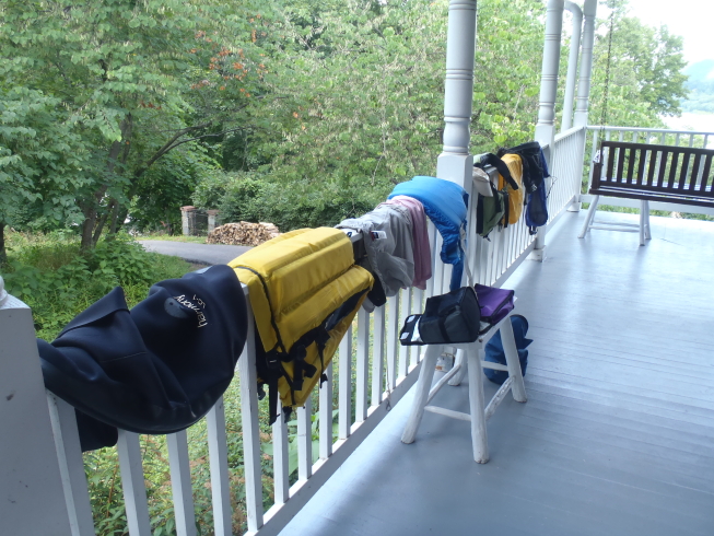
The air was drier on Saturday than it had been on Friday. We spread out our wet clothes and equipment to catch the light breeze.

Another view of the house with our wet gear on the porch railing.

Closer look at the old church ruins.

While waiting for dinner, Dan and I took a stroll through the ruins . . .


. . . onto the AT . . .
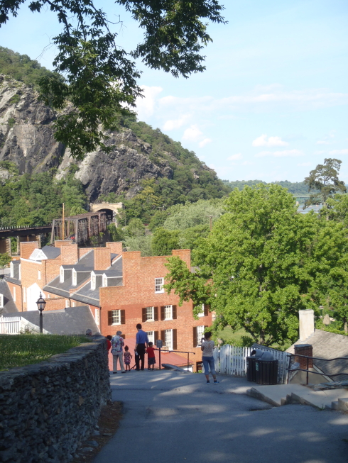
. . . and down a steep, narrow street into historic Harpers Ferry.


After I captured this snap of an informational diagram showing the location of our rental house in relation to the AT and Harpers Ferry, my camera ran out of battery power, so that’s it for this round of adventure photos! There wasn’t much to report after this point, anyway. Dan and I strolled around Harpers Ferry, which was a major tourist trap but full of nicely-preserved old buildings. We followed the AT across the pedestrian-rail mixed-use bridge, then went west on the C&O Canal Trail for about twenty minutes before turning around and coming back for dinner. After dinner (and s’mores!) we packed up the car and headed back to Charlottesville.